New Landscape Park in the Coastal-Karst region, Slovenia.
March 2018 - the municipality of Ankaran and the Ministry of environment and spatial planning of Slovenia, signed an agreement for the creation of the new landscape park Debeli rtič. It is the 45th landscape park in Slovenia. The park is located on the coast of the Coastal-Karst region close to the Italian border.
The Debeli rtič landscape park covers the entire peninsula between Valdoltra and St. Jernej bay, a 250 to 450m wide sea belt between St. Jernej and Valdoltra bay. The aim of creating the park was to protect the precious value of the land and marine area – landscape and flora and fauna.
The area of the landscape park is also of ecological significance and included in Natura 2000. There are six natural values, two of national significance and four of local significance: the Debeli rtič flysch cliffs and the Valdoltra, overhanging cliff, remains of an oak forest, Debeli rtič park, Saint Jernej bay – reeds. Part of the landscape park is also registered as a cultural heritage site: archaeological sites, parks and gardens, memorial buildings and sites, as well as cultural landscape, which is also part of the Register of Immovable Cultural Heritage of the Ministry of Culture of Slovenia. The area is also crucial in terms of preserving sea biodiversity and the seashore.

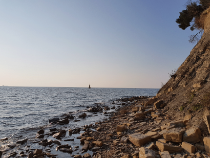
Flysch cliffs at the Ankaran Peninsula (punta). Photo byTina Primožič.
The landscape park is organised into three conservation areas:
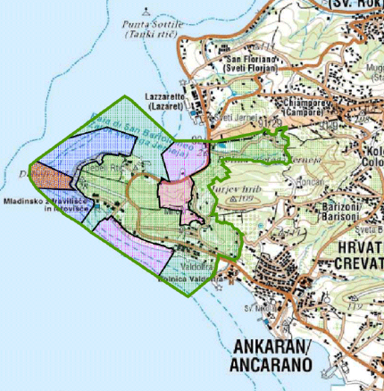
The first protected area comprises of land and sea with a shoreline at the end of the Ankaran Peninsula (Punta). The area includes the cliffs and 250 to 450 m wide coastal sea belt. The first protected area also includes the underwater ridge, which is the shallow part of the sea in the area. The second conservation area comprises of the forest in the hinterland of the St. Jernej bay and the natural preserved sea area and the seashore. This is also categorised as a natural value. The third protected area is the most urbanised and modified (Youth Health Resort; public beach, area of the Ministry of the Interior of the Republic of Slovenia; a camp site, and a residential holiday village; agricultural areas where the vineyards of the biggest wine producer in the region are located).

The green line indicates the border of the protected area. The orange shaded area represents the underwater ridge; the blue area: 1. Conservation area; pink: 2. Conservation area; green: 3. Conservation area - Image by Municipality of Ankaran
Tourism is the most influential factor on the coastal area, especially during the summer, it is a significant source of pressure on natural resources. The highest concentration of tourists is reached in June, July, August and September, which leads to conflicts. The Municipality of Ankaran, the current manager of the protected area, have worked with conservation organisations, industries and local people to establish an advisory board, a yearly action plan and a ten year management plan, on the basis of sustainable tourism. They know that if they want to preserve this rich natural and cultural heritage site for generations to come, they must take steps to manage it sufficiently.
