Tri-border region CZ-DE-PL
Green Infrastructure Strategy & Action Plan
Strategy Development
Step 1: Transnational GI assessment and identification of priorities
Analyses of the legal and strategic framework showed where aspects of GI are already being considered. The EU directives on the Natura2000 network as the backbone of GI have been transposed into national law. In addition, there are GI concepts (e.g. DE: Bundeskonzept Grüne Infrastruktur/German Federal Green Infrastructure concept), strategy documents (e.g. CZ: Politika architektury a stavební kultury České republiky/Policy of Architecture and Building Culture of the Czech Republic) or the term is already anchored in regional development plans (e.g. PL: Plan Zagospodarowania Przestrzennego Województwa Dolnośląskiego/Spatial Development Plan of Lower Silesian Voivodeship).
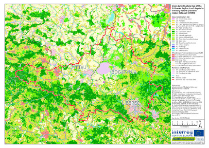
The GI mapping was carried out on the basis of full-cover regional geodata on land cover/land use. Gaps in the GI network are mainly found between the Zittau/Lusatian Mountains and the Jizera Mountains, which are due to settlements, transport infrastructure, open-cast mining and intensive agricultural use. The three largest cities Liberec (CZ), Zittau (DE) and Bogatynia (PL) have a limited amount of green space, especially in the centres. Regional stakeholders confirmed these gaps and limitations and helped prioritise activities to address them (see Step 3).

[1] Green infrastructure map of the Tri-border region CZ-DE-PL
Step 2: Functionality assessment
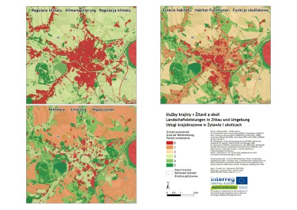
An analysis of the networking and spatial patterns of the GI elements revealed several areas within the cities and their surroundings where there is a lack of green spaces and where green routes could link smaller urban green spaces with larger green spaces in the surrounding area. On-site mapping of selected areas showed how differently certain green spaces can be characterised and how their functionality may differ. The maps of the provision of different landscape services proved to be an important basis for integrated development concepts, especially for the cities in the case study area such as Zittau. On this basis, it was possible to identify areas where new GI should be created (e.g. urban gardens) or existing GI should be enhanced (e.g. river restoration).

[2] Different ecosystem services in Zittau and surroundings
Step 3: Assessment of public benefit
Over the course of several workshops, thematic mapping was carried out together with regional stakeholders. The participants represented various target groups (including NGOs, universities/research institutions, local public administrations/authorities, sectoral agencies and planning offices). The thematic mapping identified the strengths of and threats to existing GI as well as the needs and opportunities for the creation of new GI. The issues mentioned by the stakeholders were assigned to GI benefits that could be achieved by implementing appropriate measures. Those benefits that were often identified by stakeholders as being significant became those prioritised in the strategy.
[3] Stakeholder workshop in Liberec
Photo credits: Henriette John [Header], Anke Hahn [3]
Back to GI STRATEGY & ACTION PLAN | WP3 OVERVIEW | MAIN PAGE
