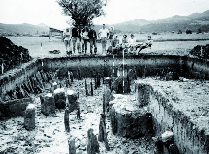
III. Prehistoric pile dwellings in the Ljubljana Marshes, Slovenia (SI)
Ljubljansko barje (Ljubljana Marshes, Ljubljana Moor) is a large wetland and tectonic depression located in the central part of Slovenia at the interface of the Alps and Karstic Dinarides, filled in with alluvial and lacustrine sediments up to 200 m thick. In the second half of 19th century first remains of prehistoric wooden structures of prehistoric pile dwellings along with other archaeological material were discovered. The oldest of these wooden settlements date back to the Mesolithic (around 5000 B.C.). The excellent preservation of organic, cultural and environmental material made the Ljubljansko barje one of the most intensively researched regions in Slovenia until today. A part of this landscape is also included in the serial property Prehistoric Pile dwellings around the Alps, enlisted in the UNESCO World Heritage List. Ljubljansko barje is a very dynamic landscape, structured by rhythms of lake level change, floods and changes of watercourses. Settlement patterns, patterns of landscape use and preservation processes are closely connected to rhythms of landscape change, especially water level and flow of watercourses.

THREATS AND OPPORTUNITIES
The pile dwellings are a tremendous source of information not only for archaeology, but also for dendro-chronology, botanic, climatology, geology and other fields of interest. The preservation of this archaeological heritage of global importance is however heavily endangered. Ljubljana Marshes constitute a very attractive area from agricultural land-use point of view and therefore is highly endangered by the interventions of local farmers e.g. building new, deep drainage channels and deep ploughing. Another endangerment consists of new and buildings erecting in the direct proximity of the pilot site.
PLANNED PROSPECTION / VISUALISATION ACTIVITIES
Within the project it is planned to integrate the data from extensive previous archaeological surveys with the data acquired from agencies, dealing with natural environment, geology, hydrology, meteorology etc. The further data will be collected by surveying the area using remote sensing techniques like airborne laser scanning (LiDAR) and aerial photography, targeted photogrammetric and geophysical surveys as well as ground-truthing surveys. The planned achievement is a comprehensive visualization of landscape in different periods, focusing on the environment and human/landscape interactions based on general landscape change model. Visualisations will cover the whole site and will be available in different forms for different stakeholders, from comprehensive visualisations in form of maps and animations on web platform (planners, local community and general public) to augmented reality applications for mobile visitors. Results will be used proposing standards of virtual use and protection of archaeological sites to be integrated in institutional guidelines and directives.
STAKEHOLDERS INVOLVED IN THE PROJECT
The important group of stakeholders involved in the project implementation will be agencies, dealing with natural environment, geology, hydrology and meteorology, providing necessary data gathered from extensive previous archaeological surveys of the pilot site. Thereafter an active participation of farmers and forestry operators, urban planning authorities as well as local population is indispensable.
REGIONAL STRATEGY
Klick here for the planned regional strategy (after project ending).
