Work Package 2
Green Infrastructure Functionality Assessment: Functionality Analysis
Landscape services capacity matrix
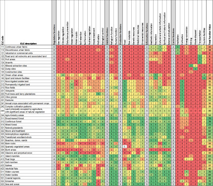
The analyses of functionality were performed by plotting capacities of GI elements and all other land use classes to provide landscape services on the above mentioned rationalized geodata stets. Especially when based on participatory approaches capacity matrices are widely used for the assessment of ecosystems services (ESS). Basically, a capacity matrix is a look-up table that connect land cover types to ecosystem services or landscape services potentially provided.
By the definition of the Millennium Ecosystem Assessment (MEA) “ecosystem services” comprise various benefits for the people provided by ecosystems. They can be divided into four categories:
- Provision services (e.g. food, fresh water)
- Regulating services (e.g. climate regulation, pollination
- Cultural services (e.g. recreation, education
- Supporting services (e.g. soil formation, photosynthesis)
In comparison to ecosystem services landscape services more take into account spatial patterns, which result from human and natural processes, as well as the social dimension. This makes the broader concept of landscape services better applicable and thus it is commonly used in landscape planning. As already described in chapter 4 (p. 17 ff) of the MaGICLandscapes Green Infrastructure Handbook (Output 1) we therefore applied the concept of landscape services. Landscape services imply diverse landscape functions which are grouped into five categories:
- Regulation functions
- Habitat functions
- Production functions
- Information functions
- Carrier functions
Therefore, the capacity values of the individual ecosystem services were matched to the corresponding terms of the landscape services classification. As an intermediate result, a Europe-wide matrix with the reclassified terminology was produced, which served as a basis for the further discussion among the project partners, containing 1320 baseline values.

Fig. 12: The final landscape services matrix including the resulting Total Function Value for each CORINE Land Cover class in central Europe
Regional Functionality Maps
By joining the final landscape services matrix with the spatial information using a GIS software (ArcGIS, QGIS), the GI’s capacity of the 30 single landscape services, the five main services and the total function value within the case study areas, are displayed based on the CORINE Land Cover data at transnational and regional level.
This allows the detection of areas of interest regarding different services or the overall multifunctionality in order to develop targeted management strategies at regional and local level to manage existing or implement new GI. The recognition and mapping of GI elements and their capacity to deliver a whole range of services allows to enhance the regional applicability and acceptance of GI initiatives and provides a crucial foundation for developing evidence-based strategies and action plans through stakeholder involvement to direct future actions and investment in GI.
Functionality Maps Kyjovsko (South Moravia/Czech Republic)
Functionality Maps Dübener Heide Nature Park (Saxony and Saxony-Anhalt/Germany)
Functionality Maps Karkonosze National Park (Lower Silesia, Poland)
Functionality Maps Tri-Border Area Czech Republic - Germany - Poland
Functionality Maps Krkonoše National Park (Liberec and Hradec Králové Regions, Czech Republic)
Functionality Maps Eastern Waldviertel and Western Weinviertel incl. Thayatal National Park (Lower Austria)
Functionality Maps Po Hills around Chieri (Turin, Piedmont/Italy)
Functionality Maps Upper Po Plain (Piedmont/Italy)
Back to WP2 OVERVIEW
Back to MAIN PAGE
