Upper Po Plain
Green Infrastructure Strategy & Action Plan
Strategy Development
Step 1: Transnational GI assessment and identification of priorities
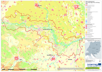
From the analysis of the Green Infrastructure Map, it emerges that the areas in which there is green infrastructure, not considering rice fields which in any case play a significant role, are limited to a fairly continuous river belt, to a widespread and frayed mosaic placed in the hilly belt and to a single point mosaic in the plain areas of both Vercelli and Alessandria. There are also some important areas such as the Bosco della Partecipanza di Trino, the area around the abandoned power plant of Leri Cavour and, of smaller size, the natural areas included in the SACs of Palude di San Genuario and Fontana Gigante.
The analysis of the planning tools made it possible to identify a series of common thematic areas that are suitable for increasing the functionality of the Green Infrastructure network in the area under examination:
- Protecting and improving the existing natural formations/elements (from the most important core areas to the linear and punctual elements).
- Improving the quality of aquatic ecosystems and increase the naturalness of the river territory (to increase biodiversity and to protect against hydrogeological risk).
- Protecting the landscape
- Promoting the development of highly sustainable economic activities

[1] Green infrastructure map of the case study area Upper Po Plain
Step 2: Functionality assessment
The connectivity analysis underlined how the river corridors and, at a higher level of detail, the minor hydrographic network, constitute the fundamental structure of connectivity in the case study area, and the scope of possible expansion of the green infrastructure network at local scale.
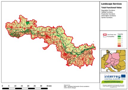
The Total Function Value Map, which provides information on the multifunctionality of the territory, drawn up considering the four considered families of landscape services (Regulation, Habitat, Production, Information) highlights, even more, the fundamental role assumed by the river territory and forest formations. The highest value is reached by spontaneous tree formations, while the river corridor is characterised by a slightly lower level.

[2] Total Functional Value of the case study area Upper Po Plain
Step 3: Assessment of public benefit
The maps created using the methodology of Public Benefit Assessment developed within the MaGICLandscapes Project make it possible to represent the level of provision of each benefit by the territory under consideration, based on the land use cartography. These maps, although each referring to a different "family" of benefits, connected to the provision of a different list of Landscape Services, do not appear, from a general point of view, significantly different: in almost all cases the fundamental role to be attributed to the river corridor and the wooded areas present in the territory is highlighted.

|

|
Public Benefits that were identified in the interaction activities with local stakeholders as priorities for the drafting of the strategy are:
- Conservation benefits
- Disaster prevention
- Climate change mitigation and adaptation
- Agriculture and forestry
- Water management
- Tourism and recreation
It should be noted that, at the scale of the entire territory, there is ample room for possible intensification in the provision of individual benefits, through an action to improve functionality and ecological connectivity. In addition, it is highlighted the importance of the conservation of all the existing natural areas (wooded areas, wetlands and river areas), which currently ensure the availability of benefits for all users of the territory of the Po Park and its Touristic Area.
Photo credits: Simone Ciadamidaro [Header]
Back to GI STRATEGY & ACTION PLAN, WP3 OVERVIEW or MAIN PAGE
