Kyjovsko
Green Infrastructure Strategy and Action Plan

|

Case study area Kyjovsko in South Moravia, Czech Republic |
Description of the area
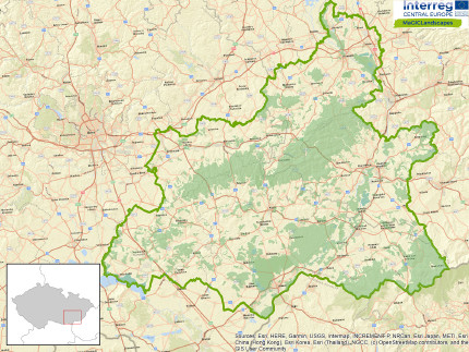
Kyjovsko is a region in South-Moravian, Czech Republic. It is an administrative district of municipality with extended competence, named by its administrative centre - city of Kyjov. The region covers an area of 470 km2 and has about 55,000 inhabitants living in 42 municipalities. It is situated in the lowlands and is characterised by undulating terrain. Most of the region is intensively used, especially for agriculture, resulting in very large, impermeable blocks of arable fields that suffer from wind and water erosion. Due to its warm and dry climate (and the terrain), the region is known for its vineyards, and to a lesser extent for its orchards, which are unfortunately gradually disappearing. Green infrastructure is mainly represented by large woodland complexes in the north and south, some remnants of dry grasslands and the unique but quickly disappearing mosaic of smallholdings. Approximately 20 percent of the region is covered by protected areas in the form of NATURA 2000 sites, significant landscape elements or small protected areas.
Issues
Kyjovsko, like other parts of the Czech Republic, was affected by socialist collective agriculture, which manifested itself among other things in land consolidation resulting in destruction of the fine harmonious cultural landscape mosaic. This consolidation dramatically decreased the number of field roads, grasslands and woody strips, woodlots and groups of trees. This has significantly reduced the permeability of the landscape not only for humans but also for wildlife. Another consequence of socialist and contemporary intensive agriculture, and also of ongoing change in climate, is increased soil erosion and the reduced water retention ability of the landscape. The reduced retention function has been perceptibly worsened by agricultural ameliorations (e.g. efforts to accelerate water drainage, watercourse straightening/canalisation and draining of wetlands).
Challenges
There are several challenges related to implementing GI in the region and in order to combat the aforementioned issues. The most pressing one is the fact that the majority of municipalities lack complex land consolidations that allow for implementation of GI. This is often due to the land owners’ reluctance to agree with these consolidations and lack of money. Another challenge is to persuade some farmers to implement anti-erosion measures. Last but not least, spatial planning and environmental protection lack complete documentation related to green infrastructure, such as a digital layer of the Territorial System of Ecological Stability (TSES). The TSES is a planned (though not completely realised) network of natural and semi-natural ecosystems that incorporates existing ecosystems and identifies where creating new ones would improve its network function. This includes connectivity, providing habitats to support species survival and increasing the positive effect of natural ecosystems on their less stable surroundings.
HOW THE STRATEGY WAS DEVELOPED
Outline of key themes, priorities and directions for the GI Strategy and Action Plan
Based on the identified needs and problems and other analyses, three main objectives were suggested: better landscape permeability, increase of water retention ability and reduction of soil erosion. These objectives are also, to some degree, included in strategic documents of the region and individual municipalities. They can be subdivided to diversifying landscape mosaic, connecting existing road/path network (with accompanying GI), enhancing organism migration, creating educational trails, creating/restoring water ecosystems and other GI elements. Their realisation would contribute to benefits stated in the table below. Measures that can help in fulfilling these goals are, for example, the realisation of planned but non-existing TSES elements, planting grassland belts (with and without trees) in erosion prone localities, building cycling paths, restoration of field roads, surveys and mapping of interesting/unique GI elements, building/restoration of wetlands and water bodies, and the renaturalisation of streams and rivers. Historical maps helped in identifying where the previous GI elements as well as where roads used to be and could be restored to help fulfil the goals. The combination of functionality assessment with other sources then enabled the prioritisation of which of the TSES elements should be realised first in order to fulfil the goals.
GI Benefit | Strategic Tools/Policies | Partners | ||||
| Community Local Development Strategy for Kyjovské Slovácko region | Municipalities | ||||
| Tourism & recreation | Community local development strategy for Kyjovské Slovácko region | Municipalities MAS Kyjovské Slovácko v pohybu (Local Action Group) Kyjovsko regional authority | ||||
| Education | Community local development strategy for Kyjovské Slovácko region | Municipalities MAS Kyjovské Slovácko v pohybu (Local Action Group) Kyjovsko regional authority | ||||
| Climate change mitigation & adaptation | Community local development strategy for Kyjovské Slovácko region | Municipalities MAS Kyjovské Slovácko v pohybu (Local Action Group) Kyjovsko regional authority | ||||
| Health & well-being | Community local development strategy for Kyjovské Slovácko region | Municipalities MAS Kyjovské Slovácko v pohybu (Local Action Group) Kyjovsko regional authority | ||||
| Water management | Community local development strategy for Kyjovské Slovácko region | Municipalities MAS Kyjovské Slovácko v pohybu (Local Action Group) Kyjovsko regional authority |
Key Players/actors in delivering the strategy and those that support its implementation
The key player and main supporter in the delivery of the strategy is the regional authority of the Kyjovsko region – Municipal authority Kyjov, Department of Environment and Territorial Planning who is also an associated partner in the project. They will have all data and outputs from the project and will be able to distribute them in the region. Some outputs will be incorporated into the development/territorial plan of the region. Other actors using the strategy and outputs will be the municipalities who can base their investment plans for GI intervention on the project’s outputs.
Expected benefits
Implementing at least some parts of the strategy will help in reducing the current problems that occur in the Kyjovsko region. The benefits resulting from implementations are; improved land and soil management/less soil erosion, an increased water retention ability of the landscape/enhanced water management, better connectivity leading to a higher resilience of the landscape/ecosystems. This implementation will also to provide more recreational opportunities and subsequently better health and well-being of local communities.

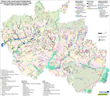
GI Strategy Map of Kyjovsko / Strategická mapa zelené infrastruktury pro Kyjovsko
Contact
City of Kyjov
Department of Environment and Territorial Planning
urad(at)mujkyjov.cz
www.mestokyjov.cz
Header photo: Hana Skokanová
Back to WP3 OVERVIEW | CASE STUDY AREA | MAIN PAGE
