Po Hills around Chieri
Green Infrastructure Strategy and Action Plan

|

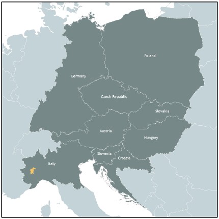
Case study area Po Hills around Chieri in Piedmont, Italy |
Description of the area
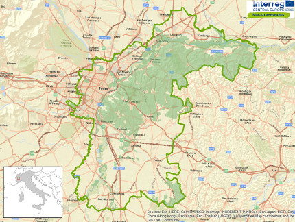
The Case Study Area (CSA) includes Turin, one of Italy’s main cities, and the surrounding peri-urban areas located on the plain near the hills to the east of Turin. Italy’s longest river the River Po also flows through the area. The Turin hills to the east are covered with woodlands and vineyards. There are many Special Areas of Conservation (SAC), both on the hills and on the plain, along the River Po. To the south of the area there is the Altopiano di Poirino and a wide plain, where the woodlands were replaced by agriculture. The area has a significant naturalistic-environmental and landscape value.
Issues
The problems in the area are manifold and include landscape deterioration (urban and peri-urban areas particularly), urban expansion and sprawl in the plains and in the hills along the main transport routes. The loss of biodiversity and reduced environmental connectivity caused by soil consumption and sealing, and spread of exotic species is also an issue. The landscape has been transformed due to cereal crops and arboriculture (especially on Altopiano di Poirino) and hydro-geological fragility results in many landslides and flooding is also an issue particularly in the southern sector. In agricultural areas and in the urban/peri-urban contexts there is a shortage of GI benefits and reduced biodiversity and connectivity.
Challenges
Key challenges are the planning, management and increase of woodlands, increasing riparian/perifluvial vegetation along the hydrological network and promoting the appropriate soil and water management in agricultural, urban and peri-urban contexts to reduce soil erosion, particularly in areas of slope instability. A further challenge is the re-connection and increase in area of natural and semi-natural areas such as hedgerows, isolated woodlands and small wetlands and the rehabilitation of brownfield areas in urban and peri-urban areas.
HOW THE STRATEGY WAS DEVELOPED
Outline of key themes, priorities and directions for the GI Strategy and Action Plan
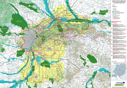
Through the analysis of workshop results we identified the final locations of the objectives to be pursued with the enhancement/implementation of GI; the planning instruments and strategies to achieve these objectives and the actors in charge of drawing up the plans / strategies (Public Institutions) and implementing them (public institutions, private citizens, organisations, associations …). Below is an extract of the table.
The final products were a map with the location of the objectives to be reached (sector/areas) and a brief description of critical issues and strategies for each area/sector; a document that collects the planning instruments/strategies useful to achieve the objectives and improve public benefits and the actors responsible for their implementation. The document provides, for each type of actor (Metropolitan City of Turin, municipalities, citizens ...), concrete indications regarding the tools to be used to pursue the enhancement of GI. For the Action Plan the steps are the same, but the evaluations are much more detailed and aimed at enhancing Arignano Lake and its surroundings from an environmental and touristic point of view.
GI Benefit | Strategic Tools/Policies | Partners | |||
| Agricultural areas: Piano di Sviluppo Rurale (PSR) [Rural Development Plan (regional)]; Piano d’Azione MAB “Collina Po” |
| |||
| LAND & SOIL MANAGEMENT Ability to mitigate the effects of soil consumption (sealing, fragmentation, impove rishment) | Ban on new land use: Piano Territoriale Generale Metropolitano (PTGM) [General Territorial Metropolitan Plan]; PRGC |
| |||
| BIODIVERSITY & CONNECTIVITY Variety level of flora and fauna and habitat connectivity |
|
| |||
| HEALTH & WELL-BEING Air quality and environmental quality | Case study area: Piano Regionale della Qualità dell’Aria (PRQA) [Regional Air Quality Plan]; Piano Regionale Mobilità e Trasporti; PUMS; PRG dei Comuni | Regione Piemonte: PRQA; PR Mobilità e Trasporti | |||
| TOURISM & RECREATION | Case study area: PUMS (Coordination and enhancement of cycling and hiking routes) | Regione: Coordination and enhancement of cycling and hiking routes |
Key players/actors in delivering the strategy and those that support its implementation
The following actors are supporting the implementation of the strategy and action plan; municipalities through the drafting and implementation of the rules of the PRGC and Urban Green Plans or Regulations, Po Park Management Body through the drafting and implementation of Plans/Programmes (Management Plans of the of Natura 2000 Sites; PTO; Program of the Piedmontese Po shared forest; update of Park Plan). The Metropolitan City of Turin will include the strategy in its Strategic and Territorial Plan and in other documents like Guidelines). For the Action Plan the key actors are the 4 municipalities in the area (Arignano, Andezeno, Marentino and Chieri) and a cultural/environmental association (Arignano Lake conservation committee).
Expected benefits
The inclusion of rules and regulations in the various territorial and urban planning tools will help to protect and implement GI and their benefits such as: prevention and mitigation of soil erosion/instability, ability to mitigate the effects of soil consumption (waterproofing, fragmentation, impoverishment), improvement of air quality and environmental quality; the Action Plan is aimed at the environmental and touristic enhancement of Lake Arignano area; it will consist of concrete actions.
Download the Full Strategy Here (Italiano)

GI Strategy Map of case study area Po Hills around Chieri
Contact
Città Metropolitana di Torino
Dipartimento Ambiente e Vigilanza Ambientale
Direzione Sistemi Naturali
Dott. Gabriele Bovo
gabriele.bovo(at)cittametropolitana.torino.it
www.cittametropolitana.torino.it
Header photo: Gabriele Bovo
Back to WP3 OVERVIEW | CASE STUDY AREA | MAIN PAGE
