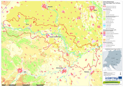
Upper Po Plain, Italy
The River Po case study area corresponds to the system of the Vercellese-Alessandrino River Po protected areas lying along the River Po. The area ranges for nearly 90 kilometres along the River Po’s banks in the Piedmont region, North-western Italy, with a succession of different environments linked by the course of the river. A total of 24 municipalities are included in the case study area, distributed among the provinces of Alessandria, Torino and Vercelli.

Upper Po plain case study area
Many protected areas can be found within the case study area. Some are natural reserves belonging to the System of protected areas of the River Po: “Isola Santa Maria”, “Ghiaia Grande”, “Confluence of the Rivers Sesia and Grana and Garzaia di Valenza”, “River banks of Casale Monferrato”, “Bric Montariolo”, “Boscone”, “Confluence of Tanaro river”; three other protected areas are located in the mosaic of the Vercelli rice fields: the natural reserves “Palude di San Genuario” and “Fontana Gigante” and the natural park “Bosco delle Sorti della Partecipanza di Trino”. The listed protected areas are associated to an external contiguous area which links the areas with the surrounding territory.
Several Sites of Community Importance (SCI) and Special Protection Areas (SPA), belonging to the Natura 2000 Network, can be found in the area and largely overlap with the above mentioned protected and contiguous areas. They are designated to protect habitats and species typical of lowland and fluvial environments, some of which are severely threatened at the European level: habitat 91E0* Alluvial forests with Alnus glutinosa and Fraxinus excelsior (Alno-Padion, Alnion incanae, Salicion albae); 9160 Sub-Atlantic and medio-European oak or oak-hornbeam forests of the Carpinion betuli; habitat 3270 Rivers with muddy banks with Chenopodion rubri pp and Bidention pp vegetation; the largest Italian nesting sites of several heron species such as Ardea purpurea and Nycticorax nycticorax and some nesting Botaurus stellaris.
Despite this area being characterised by strong human activities, this reach of the lowland River Po still retains many natural elements. In the upstream section of the area, the landscape is characterised by the contrast between the Monferrato hills and Vercelli’s rice plain. Rice fields, in particular, represent the dominant farming activity in lowland sections, together with large forestry activities (poplar). Some energy plants and other industrial facilities are also present.
People have a lesser presence in the Monferrato hills leaving space for wooded areas and meadows though some extensive cultivation does exist in the form of the area’s vineyards. The landscapes created where these hills meet the River Po are called ‘Rocche’ and have sharply eroded cliffs and are sparsely vegetated.
Downstream the town of Casale Monferrato the River Po is enlarged by the waters of the Rivers Sesia and Tanaro and it acquires the morphology typical of large lowland rivers, shaping large gravel beds, islands and lateral wetlands.
Download Flyer of the case study area river Po plain (in Italian)
View Regional Workshops in the Upper Po plain (in Italian)
Regional green infrastructure maps of the Upper Po Plain
Green infrastructure functionality maps of the Upper Po Plain
Green Infrastructure Strategy & Action Plan Upper Po Plain
If you are interested in the pdf version of all maps of green infrastructure which are linked above feel free to contact Gian Luigi Rossi from the Italian National Agency for New Technologies, Energy and Sustainable Economic Development (ENEA) in Saluggia/Italy.
VIDEOS
Video "Progetto Europeo MaGICLandscapes" (TGR Piemonte 2019, in Italian)
Video "World Metropolitan Day Torino 2019" (in Italian)
Header photo: Simone Ciadamidaro
Back to CASE STUDY AREAS or MAIN PAGE
